LANDSAT-TM
Image taken on 6th July 1991 at 9:35 a.m.
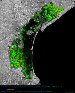
VEGETATION
DISTRIBUTION ON THE BOTTOM OF THE LAGOON
In advanced rotting
In rotting
Distribution of the lagoon vegetation
along the water column used to identify the bottom vegetation
To visualize more details click on the image.
The
original images, in TIFF format, werw made available by
Consorzio
Venezia Nuova - Information Service.
Le
immagini originali, in formato TIFF, sono state messe a disposizione
dal
Consorzio
Venezia Nuova - Servizio Informativo.
